Showing posts with label Crater. Show all posts

Thursday, April 9, 2015

Mount Batur and Lake Kintamani, Bali

Lake Kintamani and Mount Batur
In mountainous areas around Kintamani, there is Mount Batur and the crater lake and the natural hot springs that exist in Toyabungkah. The cool mountain air with great views in all directions, as beautiful as the presence of several important temples, which have made Kintamani become one of the most unforgettable places in Bali tourist agenda.

Mount Batur is one small volcano, but its location is in the middle of a large crater diameter 14 km. Mount Batur is located adjacent to Lake Kintamani. Those Shaping crescent surrounded by high walls of the crater rim. The size of the crater steepness will make you imagine the massive eruption of Mount Batur which happened ten thousand years ago.

The mountain is still active. Bali residents remember the eruption in 1917. The eruption has taken thousands of lives and destroyed hundreds of houses Batur Tua village at the base of Batur caldera. People who are still living eventually fled to the Batur village and now called (Kalangayar, which means a new one.) Pura Danu Batur previously also at the bottom of the caldera in the south of Mount Batur also moved.

Lake Kintamani and Mount Batur
The charm is offered to tourists is the natural landscape. The landscape is a combination view of Lake Kintamani and Mount Batur. They stand in the middle of the caldera make this area become one of the most favorite tourist destinations in Bali.

If you have more time and you like adventure or photography, you should stay in the area around Mount Batur. Then the next day climbing Mount Batur or Batur caldera in the east of Mount Batur while enjoying the beautiful sunrise coming out from behind Mount Rinjani in Lombok.

Kintamani tourist attraction can be reached about 2 hours drive from Denpasar or Kuta. You can also pass through when you want to travel to Lovina.

Sunday, April 5, 2015

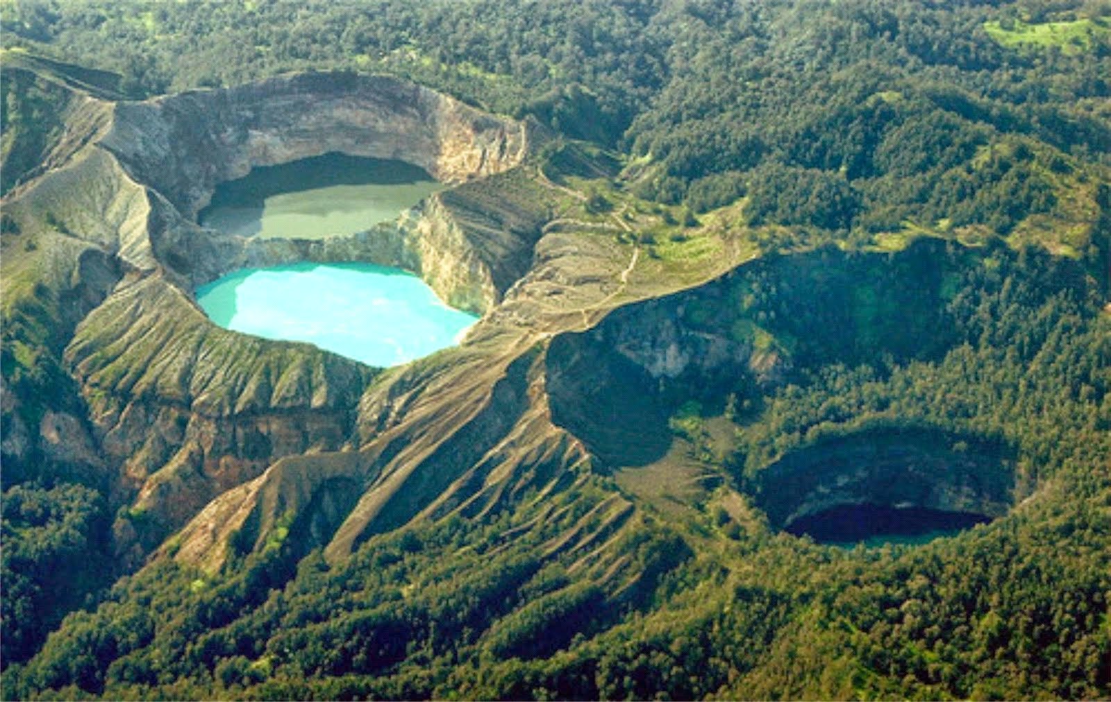
Beautiful Three Colour Lakes, Kelimutu

Beautiful Kelimutu Lake - Flores
Flores Island in East Nusa Tenggara has some attractive tourist place. Lots of amazing natural beauty of the island. One of them was at the peak of Mount Kelimutu, namely Kelimutu Lake. Kelimutu Lake is often referred to as the Lake Three Colors, because this lake has three different colors. The lake's water color change over time.

The uniqueness of colors that makes the tourists visiting this attraction. Kelimutu itself is a combination of the word "keli" meaning mountain, and "mutu" which means to boil. The lake is located in the village Pemo, District Flores, Ende, East Nusa Tenggara. To reach this lake, tourists have to travel about 45 miles from Ende or 13 miles from the village of Moni.

Lake Flores popularized a Dutch citizen named Van Such Telen in 1915. The beauty more widely known after it. Bouman describes the beauty and the lake water discoloration in his writings in 1929.

Kelimutu Lake Flores
Scientifically discoloration Kelimutu is a factor, mineral deposits, moss and rocks in the crater and also the influence of sunlight. Scientists believe that the lake was formed from volcanic eruptions in ancient times. This phenomenon has attracted the attention of geologists because of the existence of the lake which has three different colors but it was in this same mountain.

Lake Kelimutu is part of the Kelimutu National Park. The highest point of the park is 5.679 feet, located in Kelibara Mountain (1,731 meters) and Mount Kelimutu 5,544 feet or (1,690 meters). Kelimutu National Park is home to around 19 species of endangered birds including Punai Flores (Treron florists), Wallacea Owl (Otus silvicola), ikatan rimba-ayun (Rhinomyias oscillans), Kancilan Flores (Pachycephala nudigula), Sepah Kerdil (Pericrocotus lansbergei), Tesia Timor (Tesia everetti), Opior Jambul (Lophozosterops dohertyi), Opior Paruh Tebal (Heleia crassirostris), Cabai Emas  (Dicaeum Annae), Kehicap Flores (Monarcha sacerdotum), Burung Madu Matari  (Nectarinia solaris), and Flores Eagle (Spizaetus florists).


Tuesday, March 31, 2015

Beautiful Ijen Crater

via javassunrise
This is one of Indonesia's incredible natural beauty that have led many tourists from many countries. Here you can see an amazing wide crater lake along the blue flame of sulfur at night. In addition to being a tourist destination hiking, Ijen Crater is also a traditional sulfur mining areas up and down the former arena eruption crater which is still active.

Mount Ijen have a location in the Crater Ijen Park and Park Reserve Ijen in the district Licin and sub-district Klobang and Bondowoso regency. The mountain is located 2,368 meters above sea level where the peak is a series of volcanoes in East Java such as Bromo, Semeru and Merapi. Ijen Crater is the largest sulfur mining areas in East Java are still using traditional means. Ijen has sublimat source of sulfur which seemed never runs out used for various industrial chemicals and purification of sugar.

Ijen Crater is one of the world's most acid crater. With the caldera wall as high as 300-500 meters and wide crater reached 5466 hectares. The crater in the middle of the caldera is the largest on the Java Island with a size of 20 km. The size of the crater itself is around 960 meters x 600 meters. The crater is located at a depth of more than 300 meters below the caldera wall.

Views of the crater is so amazing when exposed by the morning sun emits turquoise shiny. The light coming from behind Mount Merapi, so do not miss to be captured by the camera. Water crater bluish green quiet but you are not allowed to descend because water crater volume of approximately 200 million cubic meters heat at 200 degrees Celsius. The degree of acidity is very high crater close to zero so that it can dissolving the the human body even clothes quickly.

Early morning at 01.00, when the sun had not refract light to open the beauty of this crater lake, there is another miracle presented Ijen. Under the crater glow blue flame (blue fire) of liquid sulfur flowing endlessly to be dried by the wind then became a rock and chopped. Chunks of sulfur is then placed on two wooden baskets and dipakul down the mountain as far as 3 miles. Not a light load because the weight of the basket can carry up to 100 kg.

In the southeast crater there are solfatara field which is the crater ijen lake wall. In the western part of the ijen crater there is a dam which is upstream of Banyupait Lake. Field solfatara Mount Ijen always release of volcanic gases with a high concentration of sulfur gases and smell that sometimes sting. Dam Ijen is part of the attraction interesting but not always visited by tourists because of the way to get there is quite difficult and often damaged by landslides. Ijen Crater Dam is a concrete building built since the time of the Netherlands and is intended to regulate the water level of the lake so as not to cause flooding acidic water. But the dam is now not working because the water never reached the door of water due to water seepage under the dam lake.